Supporting Local Recording Communities: Spotlight on…Sheriff Hutton Hedgehog Group
As well as collating, managing and disseminating ecological data - the core functions of a Local Environmental Records Centre - NEYEDC also works closely with the local recording community across North and East Yorkshire. We support small, local groups who are interested in recording the biodiversity of their patch, whether at the field, nature reserve or parish scale, as part of our charitable objective: ‘to advance the education of the public by producing a database of ecological information for North and East Yorkshire’.
Our ‘Spotlight on…’ series will highlight the work we do with different types and scales of local recording communities, from making maps and flying our habitat mapping drone to helping to organise bioblitzes and recording events.
Today our recording community spotlight is on Sheriff Hutton Hedgehog Group, an offshoot of Sheriff Hutton Nature Group, located around 10 miles north-north east of York. The Nature Group was started post-covid and has approximately 60 active members. They hold regular evening talks and outdoor activities in the summer months and engage with other organisations in the region including the Yorkshire Wildlife Trust and the Howardian Hills National Landscape.
Background
We first had contact with the group through one of their organisers and volunteers, who was involved with our moth trapping projects in 2022 and 2023. They reached out explaining an interest to develop a hedgehog recording project within Sheriff Hutton and surrounding villages, an offshoot from the original Nature Group, in the summer of 2024. Since then, we’ve been in regular contact with the Hedgehog Group and provided a range of support to aid them in running their project.
Initial Mapping
As with many of our local groups, the first thing we were able to provide was a search of background records of Hedgehog from the village of Sheriff Hutton itself and some surrounding villages to provide a baseline and give the group an idea of how often the species had been recorded in the past, and where. Initially, these were static maps. We provided a first set of mapping in December 2024, and provided some different options to illustrate the impact of high-resolution and low-resolution records.
Recording guidance
Part of the group’s project involved encouraging recording of Hedgehog in Sheriff Hutton and surrounding areas. We provided the group with a basic template for the fields that we’d need to ensure high-quality records and also provided guidance on the record types that they could include – for example, live sightings, road casualties, dead animals, field signs (such as droppings) and casualties taken into care or rehabilitation. The group were happy to share their records with NEYEDC for inclusion in our reporting database.
Updated mapping
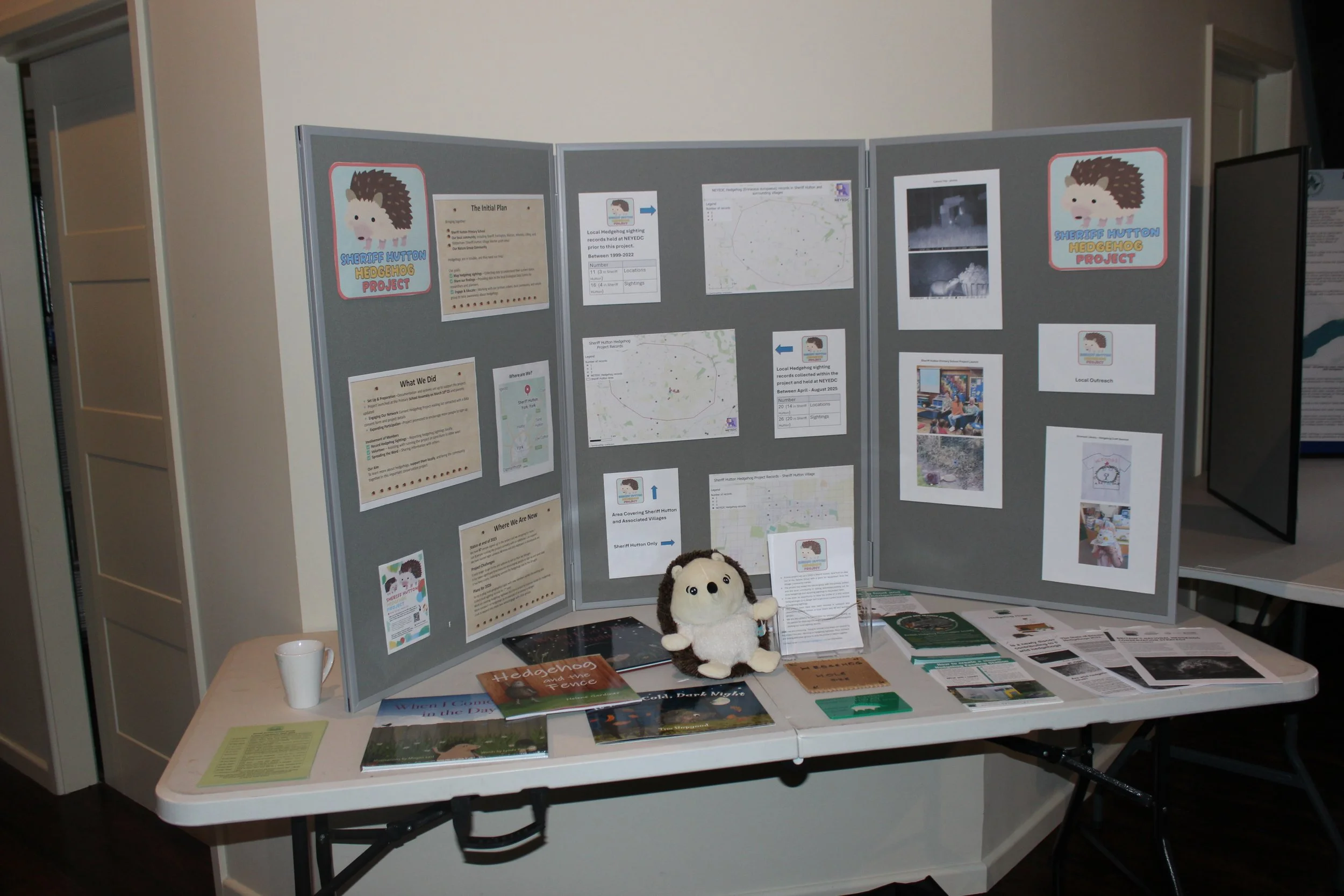
In August 2025 we provided the group with more mapping, this time including records made by the group so far, so they were able to see their new records alongside the existing records for the area. The group brought this along to a display at our conference in December 2025.
Camera traps
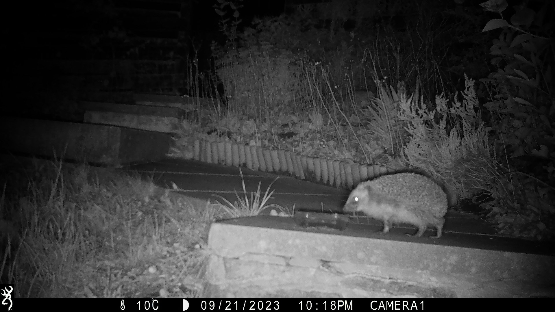
In mid-2025 were also able to provide three camera traps to the group to share amongst the local community, to provide a different avenue for recording and gain insight into the activity of local Hedgehogs!
Interactive mapping
As the project has progressed, NEYEDC and Sheriff Hutton Hedgehog Group re-assessed the species point mapping previously provided and determined that given the relatively large recording area and small, isolated villages, it was challenging to see and compare records over the full project area and see villages of interest on the base mapping. Alternatives to an overview map as had previous been created would be the provision of numerous zoomed static maps, which also didn’t provide the full picture.
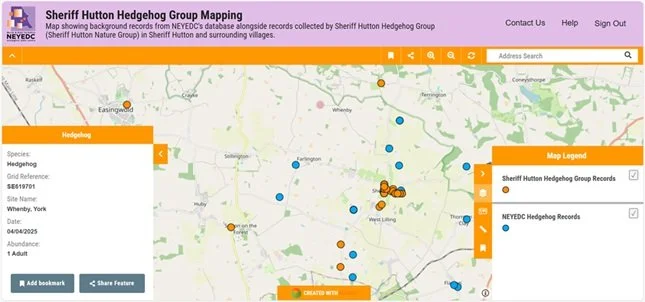
Instead, we decided to use the GIS layers created for the static mapping and instead create some basic interactive mapping available through Mango Maps for the group. Mango is a system that provides simple, accessible and professional GIS mapping, an alternative to less user-friendly systems like Esri. The screenshot below shows the mapping in its current form.
Users can toggle between the two provided layers – Sheriff Hutton Hedgehog Group Records, and NEYEDC Hedgehog Records – pan across the map investigating different areas and villages and find out basic information about each record ‘feature’ by clicking on it.
We hope that this alternative mapping will allow the project to extend and go strength to strength, covering a larger area without compromising the ability for the group to see their records and have mapping available to share with volunteers, other groups, and potentially funding sources.
In return, the group’s records are a valuable addition to our decision-making database. This is available to partner organisations through either Service Level Agreements (North Yorkshire Council, Environment Agency, Yorkshire Water) or Non-Commercial Data Licences (Humber Forest, Woodland Trust etc.), or through our Ecological Data Search service which informs the planning process.
Local Groups Support
We now have a standard offer of support that we can provide to local groups. If you are interested in finding out more, see our Local Groups page here.